Best Handheld GPS 2021
In this Guide
Camping and hiking trips are so much fun, but getting lost in the woods is not something you want to be doing. If you’re heading off the beaten track, mainly if you’ll be out of cell range, having a handheld GPS in your kit is a must. There are many great options available to make sure your adventure outing goes smoothly without any scary incidents taking place. We have compiled for you a list of comprehensive handheld GPS reviews to help you pick the best GPS for all your outdoor needs.
How to Choose the Best Handheld GPS?
Battery life
Considering you’ll likely be relying on your handheld GPS tracker to navigate — as well as help you find your way if you’re lost — battery life is incredibly important. The type of battery is important, too; rechargeable batteries can be more convenient, but swappable batteries mean you can carry an extra set on the go.
Buttons or Touch Screen
Touch screens aren’t as common as they are now, but some people still prefer them over buttons. Having a touch screen does get rid of the buttons and this offers you more real estate for a bigger screen without increasing the overall dimensions. Some touch screens can get a little difficult to use with gloves or with wet fingers. Buttons mean you get a tactile response, so you know you’ve pushed the button even if you’re wearing gloves.
If you want to see plenty of detail without having to zoom in too much, then you’re going to need a decent size screen. Having to squint and zoom means you’ll lose perspective, making it tough to know where you are on the map. A bigger screen creates more bulk, and weight as well as shorter battery life, so there is a trade-off. The screen needs to be sunlight-readable and anti-glare, with backlighting for use at night. Having a big screen doesn’t necessarily mean it’ll be easy to read. The resolution is important too. The higher the resolution, the finer the detail. You should aim for the 240×320 or 240×400 pixels range if you want to get the full benefit from your topo maps
Map features
It may seem like mapping software is pretty standard, but you’d be surprised how many features you can add on. Do you want topographical maps? What about built-in geocaching information? If you spend a little more, you can get a really nice set of maps for your device.
Weight and Dimensions
When you’re hiking, you want to carry as little as possible so as not to be overburdened. That extends to your handheld GPS. Most of these devices are pretty lightweight, but you want to make sure you’re making proper tradeoffs. A tiny device might have too small a screen to be able to see in bright sunlight. As with anything that goes into your pack, you’re aiming for small and light. The problem is with reduced weight and size comes reduced functionality. To be useful on the trail, your device needs to have a decent-sized screen and – crucially – batteries that will last for your whole trip. Touch screen GPS devices get rid of weight and bulk by dispensing with the buttons. If you only need minimal functionality to help you find your way back, or simple waypoint navigation, then go as small as possible. If you need full-featured TOPO navigation, then you’ll need something a little bigger.
Speed
PS units work by communicating with satellites orbiting the earth designed to read and triangulate signals sent from the unit. In the United States, the Department of Defense manages the GPS network, a series of 33 satellites orbiting the earth designed to transmit both positional and timing data. When a GPS unit contacts at least four satellites, it can pinpoint your position with a decent degree of accuracy, although terrain and conditions can affect this. The more satellites, the faster you can track a position, and the better the accuracy. All handhelds also use the WAAS (Wide Area Augmentation System) to increase accuracy. Satellites send signals to WAAS master stations on the ground. This message is then relayed to compatible receivers (like GPS units) to provide a much more accurate estimate of location. GPS units that use GLONASS, GPS, Galileo, and WAAS have the best reception.
Top 10 Best Handheld GPS 2021
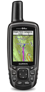
1) Garmin GPSMAP 64st
Check Garmin GPSMAP 64st on Amazon
| Pros | Cons |
|---|---|
| Sturdy build and waterproofing | Bulky |
| Large buttons that work with gloves | Lengthy setup process |
| Access to high-resolution topographic maps with 8 GB memory space | Small screen |
| 1-year BirdsEye Satellite Imagery subscription |
Specification:
- Screen Resolution: 160 x 240 pixels
- Display Type: 65-K color TFT Display
- Battery: Two AA batteries (not included) NiMH rechargeable
- Water rating: IPX7
- Memory: 8GB
- Product Dimensions: 2.4 x 6.3 x 1.4 in.
- Weight: 9.3 oz.
Key Features:
The GPSMAP 64st is a great device, especially for avid hikers, offering an easy-to-use interface, long battery life while also providing portable GPS for hiking. This device uses an external quad-helix antenna coupled with very sensitive GPS and GLONASS receivers. The receiver picks up your position fast and works well even in deep canyons or under dense tree canopies. The GPSMAP 64st has a rather clunky build with the aesthetic of an old-school walkie-talkie. Regardless, the unit fits comfortably in the palm, and the rubberized exterior and textured ridges give it an excellent, non-slip finish. The GPSMAP 64st comes with a carabiner to easily strap to a backpack or a jean back pocket for when you’re not using it. This GPS should be able to take an accidental soak in a shallow stream without leaving hikers high and dry. The simple keypad is wonderfully easy to use, but it does take a while to get used to before navigating the system becomes second nature. The buttons do give the device a realistic look in the touchscreen era; however, these too add trail merit and all-weather functionality, making it easy to navigate the system even while wearing a thick pair of gloves. If you like tracking your vitals then the Ant+ function will allow communication with heart rate monitors, pedometers, and a range of other devices.
The 64s uses two AA batteries to deliver an average 16-hour battery life but only if you turn the Bluetooth and GLONASS off. You could also get the optional rechargeable battery pack that will charge while in the device.
2) Garmin Montana 680

Check Garmin Montana 680 on Amazon
| Pros | Cons |
|---|---|
| Large 4-inch sunlight-readable screen with vibrant colors | Quite large and heavy |
| Rugged, waterproof design | |
| Simple to use touch interface | |
| 3GB memory capacity is more than sufficient for maps and logs |
Specification:
- Display Type: 4-inch dual-orientation
- Battery: up to 16 hours (lithium-ion); up to 22 hours (AA batteries)
- Memory: 3 GB
- Product Dimensions: 1.4 x 2.9 x 5.7 inches
- Weight: 10.2 ounces
Key Features:
The Garmin Montana 680 is the best way to spend your money on a handheld GPS that is multipurpose and, thus, an excellent investment. Capable of picking up GPS and GLONASS, its high-sensitivity, WAAS-enabled GPS receiver, Hotfix satellite prediction, and GLONASS support locates your position quickly and precisely and even maintains its location even in heavy cover and deep canyons. At 10.2-ounces, it’s slightly more substantial than most of its competition, but with a sizable four-inch dual-orientation and glove-friendly touchscreen display, it offers a broad view of the world around you. There’s just one button on the side for power, while the rest of the functionality is all handled on display itself (although it lacks multi-touch, which means operating the show requires just one finger). It offers a great touchscreen display with one of the biggest screens on a handheld GPS unit. The touchscreen is easy to use, and the navigation is very intuitive.
In addition to an eight-megapixel camera, Garmin pre-loads more than 100,000 topographical maps, 250,000 worldwide geocaches, as well as includes a one-year subscription to Birdseye satellite imagery. It’s 8-megapixel digital camera is perfect for higher quality images so you can make the most out of your fun excursion and remember it also! Add in a three-axis compass, barometric altimeter, and automatic geotagging of photos, and you’ve got a bevy of options beyond just the standard GPS tracking. Additionally, Garmin comes with a Track manager that can navigate through waypoints/routes/track logs to give you a clear and safe path. Garmin adds extras like trip pre-planning with their basecamp software so that you can share it with friends or family. Supplied with a rechargeable lithium-ion battery pack, it will also work with 3 AA batteries as a backup, which will give you a great battery life of around 16 hours.
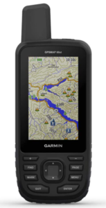
3) Garmin GPSMAP 66st
Check Garmin GPSMAP 66st on Amazon
| Pros | Cons |
|---|---|
| Excellent reception | Expensive |
| Large buttons | Bulky |
| Big screen | Complicated connectivity between devices |
 Smart notifications and connectivity Smart notifications and connectivity |
Specification:
- Screen Resolution: 240 x 400 pixels
- Display Type: Large, 3” sunlight-readable color display
- Battery: 2 AA batteries
- Memory: 16 GB
- Product Dimensions: 6.4 x 1.4 x 2.5 inches
- Weight: 8.2 ounces
Key Features:
The Garmin GPSMAP 66st is the king of accuracy and reliability with a powerful, quad-helix antenna and connects to more satellite networks than most other models. It is more reliable and accurate than much of the competition. Even in less than ideal locations, we were able to lock into great reception. This unit was secure nearly everywhere: from slot canyons of the Southwest, into whiteouts of the Pacific Northwest. This handheld GPS also comes with 16GB of internal memory — more than double most other units — and comes with a Birdseye Satellite Imagery subscription and TOPO maps. With free access to Birdseye Satellite Imagery and direct-to-device downloads, you can have access to preloaded TOPO U.S., and Canada maps with no annual subscription. It comes fully equipped with multiple Global Navigation Satellite Systems (GNSS) support to track your travels in more challenging environments than GPS alone plus a three-axis compass and barometric altimeter. The Garmin provides the best GPS navigation for hiking because it is the most accurate handheld GPS for surveying. The Garmin also offers expanded wireless connectivity, supports Active Weather for up-to-date forecasts, and animated weather radar and Geocaching Live for mobile syncing and updates. You can then receive Active Weather updates for real-time forecast information, including predictive maps for temperature, wind, precipitation, and clouds. It also provides live weather radar so you’re aware of inclement weather that can affect your outdoor adventures.
As to be expected, all of this capability carries a hefty price tag. If you plan on a lot of expeditionary travel or need a highly accurate, handheld GPS unit for field research, the 66st likely fits the bill. But for many recreationists, this unit may be overkill. While it can link wirelessly to your phone, we found setting up this process to be cumbersome. While this unit may not feature a touchscreen, we appreciated the simple layout of the large buttons — this powerful, handheld GPS is easy to use, even in the most extreme field conditions. With the Garmin, you’ll be prepared for the most extreme adventures. The GPSMAP 66 series offers up to 16 hours of battery life in GPS mode and 1 week in expedition mode (with 2 AA batteries). It provides an LED flashlight and SOS beacon that can be used to signal for help. It’s built to military standards for thermal, shock, and water performance (MIL-STD-810G), and it’s even compatible with night vision goggles.
4) Garmin eTrex 10

Check Garmin eTrex 10 on Amazon
| Pros | Cons |
|---|---|
| Speedy and accurate | Lack of base map |
| Large buttons | Limited capability |
| Inexpensive | Very little memory |
| Durable and lightweight |
Specification:
- Screen Resolution: 128 x 160 pixels
- Display Type: Transflective, Monochrome
- Battery: 25 hours 2 AA Batteries
- Memory: 6 MB
- Product Dimensions: 2.1 x 4.0 x 1.3
- Weight: 4.6 ounces
Key Features:
The Garmin eTrex 10 is our Top Pick as the perfect eco-friendly, entry-level option. This compact, lightweight device is easily stashed away in a pack or tossed into a pocket to carry along on your next adventure. The rugged Garmin eTrex 10 Worldwide Handheld GPS meets IPX7 standards of waterproofing and can be immersed in one meter of water for 30 minutes. So, you know it won’t be harmed by either rainfall or heavy splashing that you might experience while roughing it in the great outdoors. While it may be the absolute baseline for Garmin handhelds, it still offers the speed and accuracy of more expensive models. The unit’s ability to link to both GPS and GLONASS networks, providing stable reception, is particularly impressive. Its GPS receiver is WAAS-enabled with HotFix and GLONASS support, so you’ll always have fast positioning and a reliable signal in the middle of nowhere. It comes with a one-year consumer limited warranty. While it is great for quickly following a track and marking waypoints, that’s about where the functionality ends for this super simple GPS.
Even Garmin considers the eTrex 10 to be a “non-mapping GPS unit.” Except for major cities and borders, the preloaded base map is mostly blank. With minimal internal memory and no optional microSD slot, it’s not possible to upload even a single quad topo map to this device. However, it does have enough memory to accept full geocache files, including coordinates, descriptions, and hints. Considering you’ll likely be relying on your handheld GPS tracker to navigate — as well as help you find your way if you’re lost — battery life is incredibly important. The type of battery is essential, too; rechargeable batteries can be more convenient, but swappable batteries mean you can carry an extra set on the go. A great plug-and-play option, the eTrex 10 is an affordable means of dipping your toes into the world of GPS navigation.
5) Magellan eXplorist 310

Check Magellan eXplorist 310 on Amazon
| Pros | Cons |
|---|---|
| Simple button and joystick interface | GPS lock takes too long |
| Clear 2.2-inch sunlight readable screen with bright colors | Instruction manual lacking |
| Preloaded World Edition map with shaded relief | Menu navigation is a little fiddly |
| Rugged, waterproof housing | Weak GPS signal |
Specification:
- Display Type: Sunlight Readable Color 2.2″ Screen.
- Battery: 18 hours
- Product Dimensions: 7.09 x 10.63 x 7.2 inches
- Weight: 14.4 ounces
Key Features:
While Magellan doesn’t make the high-end handheld GPS products that Garmin does, they produce some reliable mid-range budget options like this. For a lot less than a Garmin, you get a vibrant color screen that reads quickly in direct sunlight, in a rugged, waterproof housing.
The 310 Summit Series caught our eye because it brings to the table a variety of expanded maps and functionality that you shouldn’t ignore when you’re in the market for a dedicated hiking GPS. Rugged IPX-7 waterproof GPS receiver, sunlight-readable color screen, and high sensitivity. The GPS accuracy is pretty good, although getting a GPS lock takes a while, and the signal can be a bit weak. Using the SiRFStarIII GPS chipset along with WAAS, MSAS, and EGNOS, Magellan claims it gives you up to 3-meter accuracy. We like the “suspend” mode which turns off everything except the GPS tracking. It saves battery life but lets you wake the device up with a single click.
Furthermore, it offers you 18 hours of battery life and power-saving features that let you go strong for an entire day without needing to stop to replace the batteries. The paperless geocaching enables you to download and view more than 20 unique characteristics of each cache, as well as view, search, and filter on the device
Here you can store flagship inclusion in this pack, which is the bundled-up topographic map set that Magellan calls their Summit Series maps. It gives you a detailed set of topography throughout a variety of famous hiking mountains throughout the world, which is better than a blanketed, one-size-fits-all topography approach. It does have a smooth operation with a simple main menu, intuitive contextual menus, and vibrant graphics–ready to use right out of the box. It also includes a detailed road network, water features, urban and rural land use, and a realistic shaded relief background. The user-friendliness isn’t quite as tried and true as Garmin, but that’s to be expected. It’s the bundled-up topographical maps that set this GPS apart from the rest of the Magellan line.
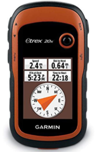
6) Garmin eTrex 20x
Check Garmin eTrex 20x on Amazon
| Pros | Cons |
|---|---|
| Entry-level device good features | At 2.2 inches the screen is a little small |
| HotFix, WAAS, and GLONASS support | No compass or altimeter |
| Full-color sunlight-readable display | Basemap is very limited |
| Plenty of internal memory and also supports microSD |
Specification:
- Screen Resolution: 240 x 320 pixels
- Display Type: Transflective, 65K color TFT
- Battery: 25 hours with 2 AA Batteries
- Memory: 3.7 GB
- Product Dimensions: 2.1 x 4.0 x 1.3
- Weight: 4.5 ounces
Key Features:
If you want a solid, GPS without the bells and whistles that drive the price up, look no further than the Garmin eTrex 20x. Despite only being 5.1 ounces, the new and improved 20x, Garmin has increased the resolution of the screen and upgraded the internal memory to 3.7GB. This gives you plenty of space to load maps (hold up to 2,00 waypoints and 200 routes), and you can also add a microSD if you need extra storage. The screen is a bit small, but the resolution and colors make it easy to read. This is an excellent entry-level, lightweight GPS. It doesn’t have an altimeter or compass – if you need them, check out the Garmin 30x. HotFix function means fast-lock, and the combination of WAAS and GLONASS result in a high degree of position accuracy. This device. It comes with a primary base map like all Garmin units, but it has the option to upload more detailed topo maps. The eTrex 20x is light, fast, accurate, and with 25 hours of battery life. Its simplicity is what is most incredible about this device. It does not support fancy wireless sharing options, an electronic compass, or a barometric altimeter, but it is quite easy to use. It’s a no-nonsense GPS unit for basic map and orienteering functions — we also think this is one of the best winter devices tested. The buttoned setup makes marking a waypoint with thin or thick gloves accurate and easy. Because it’s so small, light, and durable, you’ll find it easy to toss into a pocket and take it skiing, biking, hiking, and fishing.
The controls are comfortable, the batteries last for longer than the other units, and we could easily use it when it was wet, cold, or dark out. Some of the functions, like typing, take a little bit longer, and the lack of a barometric altimeter makes some of the altitude readings less accurate, but all in all, we think this device could be used almost anywhere. If you want an inexpensive GPS unit that packs a lot into a little, we believe this is an excellent choice. The Garmin eTrex 20x is lightweight, simple, and affordable. The batteries last a respectably long time, even in the cold, and especially if you throw two lithium batteries in the unit. You can use it when wet, cold, and also when trying to go ultralight. Our Best Buy award winner is reliable and impressive, and useful pairing with a smartphone, especially when conditions make using a smartphone tricky.
7) DeLorme inReach Explorer

Check DeLorme inReach Explorer on Amazon
| Pros | Cons |
|---|---|
| Very lightweight | Relatively small display |
| Incredible battery life | |
| Many safety features also | |
| Excellent GPS navigation for hiking |
Specification:
- Display Type: LCD 2 inches
- Battery: Up to 100 hours with Lithium Polymer batteries
- Product Dimensions: 1 x 2.4 x 5.9 inches
- Weight: 8 ounces
Key Features:
While Garmin typically dominates the handheld GPS industry, DeLorme’s inReach Explorer and its 100 hours of battery life make for an exceptional unit. Unlike Garmin’s traditional GPS units, DeLorme offers a host of features beyond typical GPS navigation, including two-way satellite messaging and SOS tracking capabilities that connect to a search and rescue center. You can create or view a route, drop waypoints, see your tracks, and navigate with the on-screen map view. In addition to this, you can even view route details such as trip distance and bearing to destination. The device also comes equipped with a digital compass, barometric altimeter, and Accelerometer. This means that you can now plan your route online ahead of time, including waypoints, and even share it with family and friends to follow along and watch your progress.
Additionally, the DeLorme acts as a GPS tracker and offers 10-minute to four-hour intervals for location transmission. If there’s one limiting factor on the DeLorme, it’s the display, which at 1.8-inches, is relatively small for today’s GPS. But, it’s worth overlooking for the longest-running battery life on this list. At just seven ounces, the DeLorme doesn’t add or remove anything that would alarm a handheld GPS shopper. Beyond the battery, the standard fare of GPS navigation is all here, including creating and viewing routes, dropping waypoints, and navigating with an on-screen map
Additionally, you’ll find route details such as distance and bearing to your location. DeLorme also offers Bluetooth pairing with your smartphone for the Earthmate mobile app, which provides additional statistics, as well as unlimited topographic and US NOAA chart downloads to your smartphone. DeLorme also includes a digital compass, barometric altimeter, and accelerometer for additional navigation support. One of the great things about this device is the various degrees of safety it offers because it allows you to send and receive 160-character text messages with GPS coordinates to cell numbers or email addresses worldwide and post updates to social media. It can even trigger an SOS, receive a delivery confirmation, and communicate back and forth with our 24/7 search and rescue monitoring center.
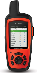
8) Garmin inReach Explorer+
Check Garmin inReach Explorer+ on Amazon
| Pros | Cons |
|---|---|
| Excellent reception | Limited navigation interface and features |
| Long battery life | Must have a service plan for messaging |
| Versatility, good at a variety of adventure | Typing is cumbersome |
| Helpful notifications via a smartphone connection |
Specification:
- Screen Resolution:
- Display Type:
- Battery:
- Water rating:
- Memory:
- Product Dimensions:
- Weight:
Key Features:
With impressively reliable reception, SOS features, satellite text messaging, and navigation via GPS, the Garmin inReach Explorer+ is a standout device for a variety of uses when you’re far from cell phone reception. You can use it for a wide range of trips, from alpine climbing in Alaska to trekking in the backcountry of Patagonia. While it is primarily a messaging and SOS device, you can also use the inReach Explorer+ as a handheld GPS. It’s easy to share your tracks and location via text messaging and social media. In addition to downloadable maps, the ability to pre-load waypoints and routes helps plan long trips over complex terrain. You can pair it with your mobile devices and use the free Earthmate app for access to downloadable maps, U.S. NOAA charts, color aerial imagery, and more. There is also an inReach Explorer+ device that adds preloaded DeLorme TOPO maps with onscreen GPS routing plus a built-in digital compass, barometric altimeter, and accelerometer.
The Explorer+ has far fewer navigation features, and a more limited interface than dedicated GPS models like the Garmin Montana 680 or Garmin Oregon 700 but works well for simple navigation and tracking. The Explorer+ is also an emergency personal locator beacon, and we caution against navigating with and draining the batteries of your lifeline. But, if you’re going to do it, this is the way to go. For those who want to go deep in the backcountry with a device that can be used for both messaging and navigation, the inReach Explorer+ is unparalleled. It possesses a 100% global Iridium satellite coverage that enables 2-way text messaging from anywhere (satellite subscription required). Furthermore, for safety and security purposes, the device also lets you trigger an interactive SOS to the 24/7 search and rescue monitoring center, and you can also always track and share your location with family and friends. (We recommend the compact inReach Mini as a personal locator and messenger if you have another means of navigating.)
9) Garmin Oregon 600
Check Garmin Oregon 600 on Amazon
| Pros | Cons |
|---|---|
| The big screen is easy to read even in bright sunlight | Hard to use with gloves |
| Exceptional accuracy and quick startup | Battery life is a little short |
| LiveTrack enabled | |
| 3-axis compass, accelerometer, and barometric altimeter |
Specification:
- Display Type: 3-Inch sunlight-readable, touchscreen display with multi-touch capability
- Battery: 16 hours/ 2 AA batteries
- Memory: 300 MB to 4GB
- Product Dimensions: 4.50 x 1.30 x 2.40 inches
- Weight: 7.40 ounces
Key Features:
This is one of the better touch-screen handheld GPS units we’ve seen. The great interface and bright screen on the Garmin Oregon are very responsive. The menu interface is easy to use, and loading maps and setting waypoints is simple. Connect it to WiFi, and you can upload your activities and routes. If you don’t mind using your smartphone data, the ‘weather’ feature is pretty cool. The Oregon line is somewhat known for its screen quality as they all feature full, super-bright (as in fully sunlight readable) displays that are all three inches. And the Garmin Oregon 600t is no different. It’s also multi-touch enabled, so you can pinch and slide to find the exact location you’re looking for. The 600t comes with ANT and Bluetooth functionality for some additional connectivity, and there are topographical maps to go with your location-based scouting to ensure that your climbs go to plan. Oregon 600t has a built-in 3-axis electronic compass with accelerometer tilt compensation to show where you’re heading even when standing still, or not holding it level. Its barometric altimeter tracks changes in pressure to pinpoint your precise altitude. You can also use it to plot barometric pressure over time to keep an eye on changing weather conditions. With its high-sensitivity, WAAS- and GLONASS-enabled GPS receiver and HotFix® satellite prediction, Oregon 600t locates your position quickly and precisely and maintains its GPS location even in heavy cover and deep canyons.
Now, there is a 650t, but as best as we can tell, the only significant difference here was the inclusion of an 8MP digital camera in the 650t. If you’re hiking, chances are you’re bringing your phone with you which almost certainly has a better cam, so you want your hiking GPS to focus on doing what it does best: positioning you on a map. So, go with the 600t, because you’ll get into Garmin’s gorgeous Oregon line for a lower price point than the 650t without the arguably unnecessary digital camera. It runs from 2 AA batteries with a quoted battery life of 16 hours. That’s more than a little optimistic and we’d recommend taking an extra set along because this unit chews batteries. You can also buy the optional rechargeable battery pack that comes standard with the 650. Ease of use and reliable GPS performance makes the Garmin Oregon a good option if you want a compact touch screen unit.
10) Garmin Foretrex 401

Check Garmin Foretrex 401 on Amazon
| Pros | Cons |
|---|---|
| The strap makes for a comfortable fit when carrying on the wrist | The User manual isn’t great |
| Great Price/Affordable | Can be a bit fiddly to use |
| Easy to read display even in bright sunlight | |
| Uses HotFix for quick position lock |
Specification:
- Screen Resolution: 100 x 64 pixels
- Display Type: LCD
- Battery: Up to 17 hours
- Product Dimensions: 1.7 x 0.9 x 2.9 inches
- Weight: 3.1 ounces
Key Features:
The Foretrex 401 is a slim wrist-mounted GPS navigator perfect for outdoor activities that require the use of both hands. Foretrex 401 combines a high-sensitivity waterproof GPS receiver, electronic compass, and barometric altimeter into a lightweight device ideal for hikers, skiers, and campers. To share data easily, you can connect Foretrex to your computer with a USB or just send data wirelessly to another device. If you need both hands while skiing, climbing, or you don’t want to reach into your pack, then you might like this wrist-mounted GPS. It only weighs 3 ounces and fits comfortably on your wrist. The monochrome, the large-font display is easy to read in the sunlight and is backlit for nighttime use. Weighing only 3 ounces, the high-sensitivity GPS works well even in canyons or in forests and uses Garmin’s HotFix to get a quick lock after first use. You can easily create and store routes. It also connects wirelessly to a cadence monitor or heart rate monitor if you’re looking to track some of your vitals. It doesn’t display a map but you can connect it to a computer and check the route you took on Google. Features a high-sensitivity GPS receiver with HotFix for improved performance and reception in heavy tree cover or deep canyons. It also keeps track of routes, tracks, and waypoints, and heart rate with add a heart rate monitor (sold separately to keep you safe). No matter where your adventure takes you, you’ll never worry about getting lost with the Foretrex 401. Foretrex keeps track of your path and displays it as a dotted trail on the screen. Just turn on Foretrex’s TracBack feature, and you can retrace your way back to where you started.
Keep track of your bearing and altitude with Foretrex 401’s electronic compass and barometric altimeter. You can save locations in memory as waypoints, so you can always find your way back to any important place, like your campsite or vehicle. And with up to 17 hours of battery life and replaceable AAA batteries, you’ll never worry about making it back. The TrackBack feature retraces the user’s path on the easy-to-view LCD display. The Garmin Foretrex 401 also supports dual position readout so you can view your current location in multiple formats with audible tones. Now you can also use the compass level when navigating to ensure maximum accuracy making this one of the most accurate GPS. Lastly, the device comes with some great features trip computer, sunrise/sunset times, hunting/fishing information, an electronic compass and, a barometric altimeter.
Important Features of Handheld GPS Explained
Electronic vs Differential Compass
The cut-off point between basic units and more powerful ones is usually the electronic compass. It displays your heading while held in place. In contrast, you have to be moving for a differential compass to work. For some, this is a great advantage — say during a whiteout next to a cliff edge. Many mountain guides prefer an electronic compass because it makes navigating faster and easier. Only the eTrex 10 and eTrex 20x don’t offer an electronic compass.
“HotFix” GPS positioning
When your GPS turns on it takes a good few minutes to locate the position of the satellites. It needs to find 3 satellites to get your position and needs a further 2 to get elevation and speed info. The HotFix feature built into some Garmin devices kicks in after around 30 minutes of use. It gathers info about the satellites it has got a fix on and can predict where those satellites will be up to three days later. The advantage is, if you switch your device off and then switch it on a few hours or a day later it gets a fix on your location a lot faster.
BirdsEye Satellite Imagery
There’s only so much you can tell by looking at your regular TOPO maps. You get a sense of direction, and shaded maps give you a fair idea of topography – but that’s about it. BirdsEye Satellite Imagery gives you high-resolution color satellite images of the area you’re in providing far more detail than a regular GPS map. This is great for planning a specific spot to set up camp or to do finer route planning. It does kind of spoil the surprise of seeing what a place looks like for the first time when you actually get there. If you want to plan each step, then it’s worth it. BirdsEye Satellite Imagery is a paid product, but some Garmin products come with a year’s free subscription.
Construction
Whatever GPS device you choose you better know that at some point you are going to drop it! Guaranteed. Also, Murphy’s Law of hiking dictates that you are most likely to get lost in the most horrible weather. Make sure you aim for a rugged design that won’t fall apart at the first bump and can survive to be out in the rain. Beveled edges around the screen, rubberized housing, and well-sealed battery compartments will all help it survive a bit of abuse.
Media
A camera, microphone, and voice recorder are nice add-ons to fully document adventures or field data. You can use these media options to mark a waypoint instead of typing one. We loved this option when looking back at our adventures. Photos also help keep you on the trail when following a track. This is especially helpful for outdoor guides or scientific surveys. While many options boast a photo viewer — even the lowly *eTrex 20x, extras like that also come at the price of the added size.
Barometric Altimeter
Once your GPS device gets locked on at least 5 satellites, it can give you your elevation but it’s not always very accurate. A barometric altimeter uses changes in pressure to calculate your height. Its accuracy will vary with the weather. Barometric altimeters also allow you to track weather patterns and trends, which is useful in the mountains when knowledge of a coming storm can be the difference between life or death. Again, in our review, only the baseline-level eTrex 10 and eTrex 20x don’t come with a barometric altimeter.
Wireless Capability and Smart Notifications
High performing GPS devices can share wirelessly — these devices come equipped with Bluetooth technology. With a compatible receiver, you can quickly send track and waypoint files to another device, wire-free. One of our main testers mentioned that this is especially helpful if you have another group that is about to embark on the same route you just finished. In a matter of minutes, you can sync up devices and share your way — we would recommend this for users intending to share track information with others. GPS devices that are capable of pairing with Ant+ bio sensors like heart rate monitors, or smartphones can be quite handy. Instead of grabbing each device separately to check your vitals – or the SMS that came through – a quick look at your GPS screen will display smart notifications for you.
Versatility & Accessories
You want the device you buy to be useful in a variety of outdoor activities. Is it light enough for trail running? Does it have the navigational features you need for going off-trail? Can you use it in all weather conditions or while wearing gloves? Will the batteries last on a long hike? Try to buy one device that is versatile enough to cater to all your expected outdoor activities. You can also extend the versatility of your device with some nice to have accessories such as:
- Rechargeable batteries and power banks
- Rugged and waterproof housing
- Lanyards or arm/wrist bands
- Dash-mount for in-vehicle use
Other Cool Features to Keep in Mind
Display trip data
A simplified version of the trip computer, which shows the elevation you’ve achieved and the distance you’ve covered on your trip.
Geocache
More and higher-end devices support geocaching. These devices allow for downloading Pocket Queries as well as logging field notes and caches
Profile options
Sometimes you want to know the distance you’ve covered. Other times, you may want to see the change in elevation you’ve achieved. Being able to select different ways to graph your information on the device – i.e., distance vs. altitude, distance vs. time, etc. is useful if you’re targeting specific training outcomes.
Route planners
Exploring is fun, but sometimes it’s nice to have someone else suggest the best route to take. If your GPS has route-planning functionality, then it takes a lot of the guesswork out of your trip.
Display position
“You are here.” Seeing your position displayed on a map makes your next move a lot easier to plan.
Frequently Asked Questions (FAQs)
Q: Do I need a GPS for Hiking?
If you’re heading onto a well-marked trail or you’re handy with a compass and a map, then possibly not. But since the chances of finding a clear trail are difficult and if you can combine the best parts of a compass and a map in one single device, then why not? A lot of hikers or geocachers depend on pinpoint accuracy and detailed topographical maps to find their way. This level of functionality, extended battery life, and other specialized features are often only available in standalone GPS units. Although smartphone development continues to close this gap and eventually to buy a portable GPS device may be tougher to justify.
Q: What is the difference between Handheld GPS Units vs. Smartphones vs. GPS Watches?
With the miniaturization of technology now allowing for GPS receivers in smartphones, it was only a matter of time before we got GPS watches. If you want full-featured, dedicated navigation functionality, then go for a handheld GPS device. If you’re looking to move fast and want to carry as little as possible, then a GPS watch is your best bet. Just don’t expect much more than basic navigation features. If you want OK navigation features but don’t want to spend too much extra money, then buy a decent GPS app for your smartphone. Just don’t drop it and be aware of battery life!
Q: Can a GPS Replace a Map and Compass? If you have a GPS, does that mean that you don’t need to know how to use a map and a compass?
Well, if you had a boat, would that mean you didn’t need to know how to swim? GPs devices need batteries. Maps and compasses don’t. When your device is working well, then there’s no need for a map. But when it stops working, you’d better have your map and compass ready. And just having them in your pack isn’t enough. Knowing how to navigate with a compass and how to read a map properly are skills that every hiker should have.
How Easy Is it to Use a Handheld GPS?
Ideally, you want to be able to switch your device on and get going straight away. Realistically, you’re going to have to read the manual or watch some Youtube videos to understand how to get the most out of it. Some units are simple to operate, while others feel like you need a Ph.D. to switch it on. Some manufacturers bury their functions in a maze of deep menu settings, while others have designed their interface more intuitively. For more full-featured devices, having a touch screen can make it easier to navigate the menus. But keyboard accuracy will be reduced in cold weather. At the very least, you want it to be easy to mark a waypoint and navigate to it without too much fuss.
Q: Preloaded or Post-loaded Maps?
You’ll see that some devices have the option of preloaded maps. Garmin uses a “t” at the end of the model name to indicate that the device has the maps already loaded. You pay extra for this, but it saves you having to go and buy the Garmin maps later and load them yourself.
There are plenty of good free maps that you can load onto your device. If you don’t mind loading your own, you can save yourself some money by buying your GPS without the maps preloaded.
Conclusion
Now that you understand what a handheld GPS is truly for, you need to consider how you would use it and which features are most important to you. You want to get the most for the amount of money you’ll be shelling out.
You’ll want a device that’s able to withstand each environment you find yourself in, whether that’s rain, snow, or wind. You should also take the time to make sure that your number 1 choice comes with the ability to load new maps to your device.
With your brand new handheld GPS, you’ll have much more peace of mind on your next big adventure!